Flickr’s Geotags Feature: Wow!
Flickr, the popular photo-sharing web app, continues to innovate with their latest feature, geotagging. Geotagging allows people to attach location-based coordinates to photos they’ve taken, essentially adding location metadata to the picture so that everybody knows where it was taken. This is a great social feature, and one that I think is worth inspecting in-depth.
At first glance, geotagging doesn’t seem that exciting. You’re simply adding coordinates to pictures, right? But after taking one look at some of the early activity that Flickr users are doing with it, combined with the additional magic of mapping and search that the Flickr folks have included, and you might wonder why every site isn’t clamboring to add tags and geotagging to their arsenal. (I bet many will soon be considering it)
Here’s the skinny on the feature…
Flickr, the popular photo-sharing web app, continues to innovate with their latest feature, geotagging. Geotagging allows people to attach location-based coordinates to photos they’ve taken, essentially adding location metadata to the picture so that everybody knows where it was taken. This is a great social feature, and one that I think is worth inspecting in-depth.
At first glance, geotagging doesn’t seem that exciting. You’re simply adding coordinates to pictures, right? But after taking one look at some of the early activity that Flickr users are doing with it, combined with the additional magic of mapping and search that the Flickr folks have included, and you might wonder why every site isn’t clamboring to add tags and geotagging to their arsenal. (I bet many will soon be considering it)
Here’s the skinny on the feature.
Tag photos with location coordinates
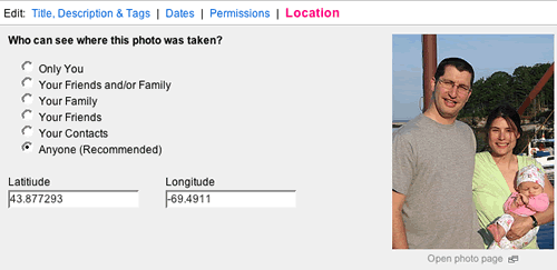
This is the first step in the geotagging process. Adding location coordinates simply means adding a longitude and latitude attributes to a photo. You know, those crazy numbers like 43.877293 Latitude and -69.4911 Longitude. This is an exact spot on the globe, allowing anybody else to find it.
Thankfully, you don’t need to know actual coordinates to use geotagging. Instead, you can simply enter addresses and Flickr figures out the rest. When you use the Flickr Organizr (no e) to organize your photos, you’ll notice a new tab called “Map”. Simply find a location by entering a street address, and the map updates to show that location. (Notice that there are already 2 pictures of mine geotagged at that location)
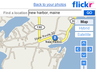
Then, simply select the photos taken at that spot and drag them onto the map at that location.
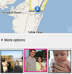
Done. You photo is geotagged. All software should be this easy!
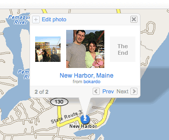
Here’s a shot of the actual geotags and their coordinates. It’s a shot of my wife and kid at a wharf in New Harbor, Maine. (also notice that you can set the privacy settings on a per-photo basis)
View or share them with others
The personal value of geotagging is clear. You can group photos according to location, and see them all on a map at once. To see your map of photos, simply access your photos using a URL like this (with username/map/ added at the end): http://www.flickr.com/photos/bokardo/map/
This is a totally cool way to browse your own pictures or share them with others. Now my parents, who live in Gardiner, Maine, can go see all the pictures I have geotagged with their address. Of course, I’ve only geotagged a few pictures so far…it does take time. (and not to mention, if you have lots of photos…discipline)
Holy aggregation possibilities, Batman!
The stuff that I’ve showed so far is really fun. Geotagging is just a great idea. But even more impressive than showing family and friends pictures tagged at a certain location is what people are already doing with aggregating geotagged photos over more than one user. It’s fun to see what photos one person has taken at a particular place, but way more fun to see what everyone has done!
The Flickr Map is the place to look for everyone’s geotagged photos. Here is the Flickr map trained on Newburyport, Massachusetts. There have been 30 photos geotagged in town so far. Considering a visit to Newburyport? Maybe you should check out the map first and see what folks are finding there.
One thing that has been bothering me about mapping software…why don’t the maps always open to wherever you are? (and if they don’t know where you are, they should ask for a default location)
And the show has just begun…
This is what I love about cool features like geotagging. People figure out the most useful ways to stretch and bend them. Ok, so we’ve got a bunch of geotagged photos and a cool mapping feature that allows us to see them. We can type in an address and see all the photos geotagged at that location. Cool. But what if we start cross-referencing those geotagged photos with regular tags? (Flickr already has great tag support)
Here are just some of the views possible with geotags and tag search. Remember, when you’re looking at these maps, think about how the ability to do this stuff came overnight. When Flickr updated with their global maps and new search functionality, combined with the tags already applied to pictures, they made this stuff possible. It’s a combinatory effect. As Stewart says…imagine what we’ll have after everybody gets wind of this and adds millions more geotagged photos!
With geotags, Flickr pushes the envelope that much forward. I think it’s a great social feature, and one whose surface has only been scratched so far. I’m excited to see what other views people will come up with, given what we’ve seen in the first few days.